NEWSPORT LIVE BLOG: Cyclone Jasper Douglas Shire preparations
MONDAY

Good Morning, welcome to Newsport’s live blog as the Douglas Shire continues to prepare ahead of the impending arrival of Tropical Cyclone Jasper.
We’ll keep you updated with all the information you need to know today, and throughout the week.
--
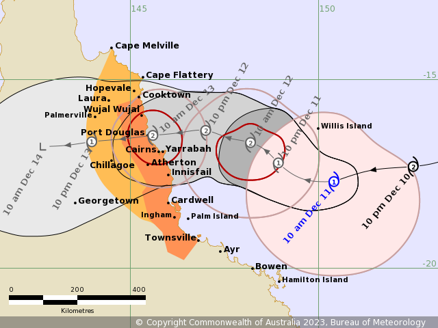
BOM latest update and advice - (11.30am)
Tropical Cyclone Jasper is currently 505km east of Cairns travelling at about 19km/hr. It’s currently a Category one cyclone with sustained winds near the centre of 85 kilometres per hour with wind gusts to 120 kilometres per hour.
Tropical Cyclone Jasper remains a category one system and may weaken slightly further today as it tracks in a general westwards direction.
Jasper is forecast to re-intensify tomorrow as it approaches the coast. The system is now forecast to cross as a category two system on Wednesday, most likely between Cape Flattery and Cardwell.
Jasper will weaken as it moves inland during Thursday towards the Gulf of Carpentaria. If the system is slower and crosses overnight Wednesday or Thursday, a slim chance remains of a severe category three crossing.
BOM advises damaging gusts over 90 km/h are expected to develop along the Queensland coast between Cooktown and Townsville, including Cairns, from tomorrow.
BOM satellite imagery has Jasper making landfall between Port Douglas and Cairns, although this tracking changes minute by minute.
Rainfall
Port Douglas is expected to receive between 1-15mm of rainfall tomorrow, 30-150mm for Wednesday, 20-150mm on Thursday and 4-45mm on Friday.
BOM has also advised that heavy rainfall may lead to flash flooding on Wednesday between Cape Flattery and Cardwell.
Lastly, BOM has advised that as the cyclone approaches the coast, a storm tide is expected between Cooktown and Townsville.
--
Sandbags availability
Sand and sandbags are available at:
Mossman – Mossman SES shed at the back of Douglas Shire Council office building.
Alexandra Bay – SES Shed
Port Douglas – At Crocs AFL Carpark, via Wharf Street
Wonga Beach – Behind Wonga RFS/SES shed
Be sure to bring your own shovel.
--
Mariners info
Regional Harbour master Cairns via Transport and Main Roads has reminded Mariners in the Douglas Shire, including Port Douglas to expect destructive winds, swell, rain or flooding forecast within 24- 48 hours due to Cyclone Jasper.
Now is the time to review safety plans (fuel, food, water and contact details), reduce wind loadings, secure vessels and anchor or moor in protected and sheltered locations, clear of other vessels and infrastructure.
Port Douglas mariners can stay Informed at Port Douglas - VHF channels 16 + 12.
--
Swiftwater rescue technicians deployed to Douglas Shire and the Far North
Fire and Rescue Service (FRS) swiftwater rescue technicians were due to depart Brisbane for Cairns just a short time ago in response to TC Jasper.
Media were on hand at the QFES State Deployment Centre to speak with firefighters before they left to assist with efforts during and post Jasper.
--
Emergency numbers
Main road closures – 13 19 40
Power outages – 13 22 96
Local disaster Coordination centre - 4098 2599
Downed power lines – 13 16 70
SES – Flood and assistance line – 13 25 00
Immediate danger - 000
--
Your messages
Have a message you need to tell us to help inform the Douglas Shire about different aspects of Cyclone Jasper? email us at [email protected], or send us a DM on our Facebook page.
--
General safety reminders
Please keep in mind Tropical Cyclones can cause:
Strong winds.
Flash flooding and rising water in creeks and rivers. Floodwater can be very deep, rise quickly and move fast.
Homes and buildings could be flooded in some places.
Fallen trees and powerlines in some places.
Power, water, sewerage and phone services could be lost in the area. They could be out for a long time.
Roads or bridges could be flooded, closed or damaged.
What you should do:
If you have special medical needs or are visiting the area, leaving now is the safest option. Check road conditions before you leave.
If you stay, check your emergency kit is fully stocked.
Battery-powered radio to listen to warnings and spare batteries.
Have a torch and spare batteries.
Tinned and packet food, bottled water, important medicine, pet food and enough clothes to last five days.
First-aid kit.
Mobile phone, charger and charged power bank.
Toilet paper, face masks and hand sanitiser.
If you have very young children, have enough nappies for up to five days, wipes, bottles, formula or baby food. Plan to not have a fridge or microwave.
Stay away from creeks, rivers and floodwater.
Move pets to a safe place. This could be high ground or inside.
Move cars to undercover on high ground away from trees if you can do it safely.
--
Port Douglas storm tide shelter
Port Douglas cyclone shelter is a purpose built and designed and constructed for the protection of vulnerable residents during the lead up to and passage of a tropical cyclone.
Douglas Shire says local residents will be informed by local disaster management groups when the shelter and other local places of refuge are open to the public to see out the cyclone.
The shelter is located at the back of Port Douglas State School.
--
Tide shelter latest
"The Port Douglas Storm Tide Shelter and other ‘places of refuge’ will be opened as needed after advice from BoM about potential storm surge danger," a Douglas Shire Council spokesperson told Newsport.
"The community will be advised if they are advised to evacuate and advised of the appropriate closest place of refuge.
"Douglas Shire does not evacuate for wind; only for storm surge danger."
--
Odds and ends
A reminder cash is always king during cyclones. When electricity or power is down businesses generally rely on cash transactions until power can be restored, so be sure to have cash available during this time.
--
Are you based in a Douglas Shire Council storm tide zone?
The Douglas Shire disaster management group has reminded local residents about the dangers of storm tide zones over the next few days.
A storm surge occurs when the pressure from a cyclone pushes down on the ocean surface which consequently forces seawater onto land.
Douglas Shire has has allocated a number of surge zones for our region. Red is the highest, followed by orange and yellow.
For further information contact DSC.
--
Newsport's EXCLUSIVE Cyclone Jasper live video/camera action
A reminder over the next few days as Cyclone Jasper makes landfall over the Douglas Shire be sure to tune in LIVE to our Four Mile Beach and Palm Cove beach cameras.
Both cameras are perfectly positioned to showcase the heavy rainfall and wind expected across the region over the next few days. Whether you're based in the Douglas Shire, interstate, or overseas, you won't miss a beat by simply clicking the below links and watching the cyclone do its thing.
You can view Newsport's exclusively located cameras by clicking here: https://www.newsport.com.au/beachcam - PORT DOUGLAS and https://www.newsport.com.au/beachcam/palm-cove-beachcam - PALM COVE
--
1.31PM: Mossman and Douglas Shire Police messages
Local law enforcement officials have reminded Douglas Shire residents just moments ago to remain informed over the next few days as Cyclone Jasper moves closer to making landfall.
"It's really important Douglas Shire residents stay across local media reports and social media to ensure they receive the latest safety information around Jasper's crossing," Mossman Police's Sarah Tulacz told Newsport.
"Everything Douglas Shire residents need to know about Jasper's arrival and impact will be regularly issued to these channels.
"We ask residents to be prepared, but not panic over the next few days."
Another local law enforcement official echoed Ms Tulacz's sentiments.
"It's really important to be prepared, it's looking like it will come across Douglas and Mossman, so all regular safety guards need to be taken," Port Douglas Sergeant and Officer in Charge Damian Meadows said.
"We also remind residents, that 'if it's flooded, forget it'.
"Another consideration is the amount of water we are going to receive.
"Keep in mind that waterways around the Douglas Shire are going to be extremely dangerous and fast flowing so please stay away from fast, running water and do not put yourself in anger type of danger."
--
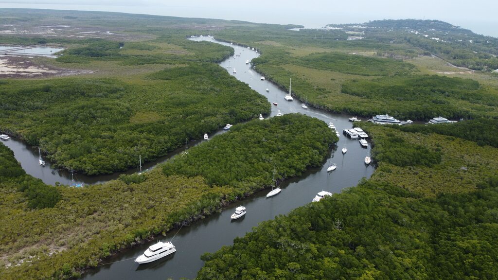
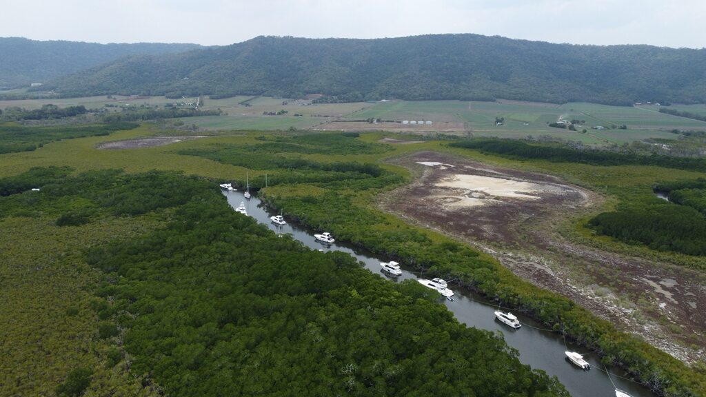
1.50PM
Newsport has been out and about today - we managed to take a drone picture of a number of boats being secured in a local inlet as Jasper continues to near the coast.
--
2.28PM: Douglas Shire road safety
Douglas Police Sergeant and Officer in Charge Damian Meadows has reminded Douglas Shire residents to stay off the roads as Cyclone Jasper makes landfall.
"I'm really encouraging motorists to essentially stay off the roads between Tomorrow (Tuesday) night and Friday. That includes traffic along the Captain Cook Highway between Cairns and Port and anywhere in the Douglas Shire.
"We really want people to stay safe and inside as Jasper passes through the Shire."
--
2.47PM: Mossman Ice bait and Tackle specialists
Mossman Ice bait and Tackle specialists have reminded residents to grab their ice requirements ahead of likely power outages across the Shire in the coming days.
Jim and Pat have reminded locals they won't be able to re-open unil power is restored so come and get your ice before they lose power.
--
2.48PM: Library closure
Douglas Shire library officials have confirmed the library will be closed from Wednesday, October 13 until Monday, December 18 due to Cyclone Jasper.
--
2.55PM: Daintree Ferry closure
Newsport understands the Daintree Ferry will be CLOSED from 2pm tomorrow, - Tuesday, December 12, until further notice due to Cyclone Jasper.
Please make appropriate arrangements to ensure you make it back home in time before the impending closure.
--
3.07PM: Cairns airport latest
Normal cyclone preparations are being undertaken at Cairns Airport in response to the cyclone warning issued by the Bureau of Meteorology for Tropical Cyclone Jasper," Cairns Airport Chief Executive Officer Richard Barker said just moments ago.
"We remain operational at this time. Regular and ongoing updates will be issued through the Cairns Airport Facebook page and on our website.
“We have enacted the Cairns Airport cyclone plan and are conducting regular cyclone committee meetings, which include representatives from key operational stakeholders, including airlines and Airservices Australia.
“Decisions around flight movements during weather events are handled by each airline. Passengers will be advised by their airline of any operational impact related to Tropical Cyclone Jasper. Customers may also wish to contact their airline directly with any specific flight enquiries.”
--
3.18PM: Cairns and Hinterland Hospital and Health Service Chief Executive Leena Singh Cyclone Jasper statement
The Cairns and Hinterland Hospital and Health Service will maintain all critical services at all hospital and health facilities, as it appears increasingly likely Tropical Cyclone Jasper will impact Far North Queensland.
The Health Service’s Disaster Plan is activated, and the Health Emergency Operation Centre is in stand up mode.
Staff across the Health Service have made preparations to ensure it can provide the necessary urgent support to the community.
CHHHS Chief Executive Leena Singh said staff had acted to ensure all facilities within the Health Service have stocks of sufficient medications, equipment, and other necessities to maintain critical services.
“At this time, we encourage all residents in the region to ensure they are prepared and have their cyclone kits ready, a stock of necessary medication and prescriptions and a maintained first aid kit,” Ms Singh said.
She said with TC Jasper threatening the Far Northern coast, elective surgery at Cairns Hospital had been postponed for Wednesday and non-urgent outpatient clinics have also been cancelled to ensure capacity at the hospital and preparation for some staff to be unable to get to work due to potential flooding or road closures.
“Emergency surgery will continue as normal, but people with non-urgent illnesses or injuries are urged not to use the hospital’s Emergency Department, which may be busy treating cyclone casualties,” she said.
“Patients without urgent or serious problems should instead contact their General Practitioner or one of the city’s medical centres.”
“We understand that it can be difficult to see a GP at this time, so we are asking the public with non- urgent conditions to please consider alternative options as a primary care point.”
--
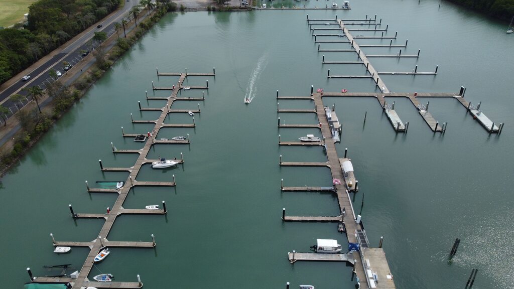
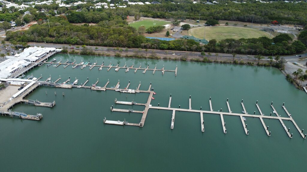
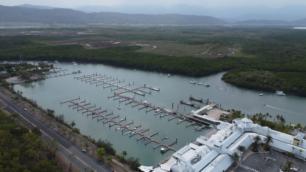
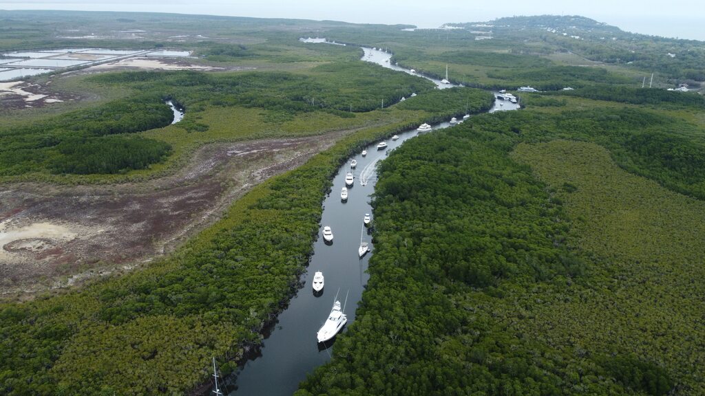
5.04PM: Newsport photos of an empty Douglas Shire
Local Douglas Shire boaties have headed relevant warnings and since placed their boats in local inlets for protection ahead of the impending arrival of Cyclone Jasper. Jamie Jansen captured a range of drone pictures just a short time ago that shows an empty Crystalbrook Marina, and a rather full local inlet.
--
5.11PM BOM LATEST UPDATE
BOM has advised Jasper remains a category one cyclone with sustained winds near the centre of 85 kilometres per hour, with wind gusts to 120 kilometres per hour. Jasper currently sits an estimated 425 kilometres east of Cairns and is currently travelling at 13 kilometres per hour.
BOM advises Jasper may re-intensify tomorrow as it approaches the coast. The system is now forecast to cross as a category two system on Wednesday, most likely between Cooktown and Innisfail.
Jasper will weaken as it moves inland on Thursday towards the Gulf of Carpentaria. If the system is slower and crosses overnight on Wednesday or Thursday, a slim chance remains of a severe category three crossing.
Damaging wind gusts over 90 km/h are expected to develop along the Queensland coast between Cooktown and Townsville, including Cairns, from tomorrow.
Damaging wind gusts may extend as far north as Cape Melville on Wednesday, depending on the movement of Jasper.
Heavy rainfall may lead to flash flooding on Wednesday between Cape Flattery and Cardwell.
Six-hourly totals between 100 to 150 mm are likely, with isolated falls of 250 mm possible along the coast and adjacent ranges. 24-hourly rainfall totals between 150 to 250 mm are likely, with isolated falls up to 350 mm possible.
As the cyclone approaches the coast, a storm tide is expected between Cooktown and Townsville.
--
5.13PM
That concludes our coverage for today. We'll re-join you tomorrow morning as Jaspers nears its coast crossing of the Douglas Shire. Thanks for joining us!

Thank you!
Newsport thanks its advertising partners for their support in the delivery of daily community news to the Douglas Shire. Public interest journalism is a fundamental part of every community.
Got a news tip? Let us know! Send your news tips or submit a letter to the editor here.
* Comments are the opinions of readers and do not represent the views of Newsport, its staff or affiliates. Reader comments on Newsport are moderated before publication to promote valuable, civil, and healthy community debate. Visit our comment guidelines if your comment has not been approved for publication.