Local residents now officially on 'Cyclone Jasper' watch as BOM confirms Douglas Shire, among others, in potential impact zone
CYCLONE JASPER

UPDATED - SUNDAY 10/12, 10.16AM
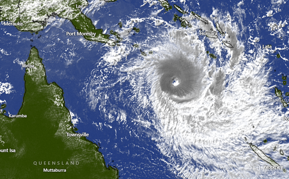
Tropical Cyclone Jasper is gradually weakening as it moves westwards through the Coral Sea and is currently located 970km east of Cairns.
Jasper may re-intensify to Category three before it crosses the Far North Queensland coast during Wednesday.
The highest risk of a cyclone crossing the coast lies between Cape Melville and Cardwell, including Cairns and Cooktown.
Gales may develop near the coast between Townsville and Cape Melville including Cairns and Cooktown from Tuesday before a potential severe tropical cyclone impact on Wednesday as the core of the tropical cyclone reaches the coast.
--
Latest Zoom earth technology tracking shows a potential, but unconfirmed crossing of Cyclone Jasper somewhere north of Port Douglas.
BOM has current predictions of 15-120mm of rainfall next Wednesday and Thursday, 6-60mm on Friday, and 3-35mm on Saturday for Port Douglas and parts of the Douglas Shire.
Newsport will have extensive Cyclone Jasper coverage throughout next week.
--
UPDATED - SATURDAY 9/12, 9.28AM
BOM STATEMENT
Cyclone Jasper is situated 1130km east of Cairns.
Severe Tropical Cyclone Jasper has started to weaken but should remain a tropical cyclone through to landfall.
Jasper should start to move to the west by Sunday towards the north Queensland coast and reach the coast by about Wednesday.
The highest risk of a cyclone impact lies between about Cape Melville and Townsville, including Cairns and Cooktown commencing on Tuesday.
As Jasper approaches the coast there is a risk of re-intensification and the potential for severe impacts.
------
FRIDAY - 8/12, 12:01PM
Douglas Shire residents continue to monitor the movements of severe Tropical Cyclone Jasper (Category 4) which just moments ago was situated 1200km east northeast of Cairns.
BOM's satellite imagery tracking has Cyclone Jasper making potential landfall, at this stage, around next Tuesday or Wednesday.
Without scaremongering or getting ahead of ourselves the Douglas Shire, like a lot of areas based on BOM’s tracking is now potentially in the vague, ever-changing and unpredictable flight path.
“Jasper is expected to approach the north Queensland coast next week,” the Bureau of Meteorology said moments ago in a written statement.
“While the timing of a coastal impact remains uncertain, the highest risk of a cyclone impact lies between about Cooktown and Townsville, including Cairns.
“As Jasper approaches the coast there is a risk of re-intensification and the potential for severe impacts.”
Local residents have been gently reminded to ensure they have an emergency kit at the ready just in case.
These items may include a battery-powered radio, torch candles, lighter and waterproof matches, water in, non-perishable food, can opener and utensils, first kit and manual, combination pocket knife, (gas) stove with fuel, cooking gear, medication, toiletry and sanitary supplies, and so on.
We’ll keep you updated as more accurate and definitive information from BOM comes to hand.
Thank you!
Newsport thanks its advertising partners for their support in the delivery of daily community news to the Douglas Shire. Public interest journalism is a fundamental part of every community.
Got a news tip? Let us know! Send your news tips or submit a letter to the editor here.
* Comments are the opinions of readers and do not represent the views of Newsport, its staff or affiliates. Reader comments on Newsport are moderated before publication to promote valuable, civil, and healthy community debate. Visit our comment guidelines if your comment has not been approved for publication.
